Predicted Eastern North Pacific Waves
FNMOC EastPAC Wave Forecasts
This data is provided by the US Navy Fleet Numerical Meteorology and Oceanography Center, Monterrey, CA.
Wave action decreases logarithmically with depth below the surface. In deep water the wave action does not reach the bottom, and the bottom has no influence on the waves.
Observed Waves at TP Outer Buoy
Predicted & Observed Waves at TP Outer Buoy
This data is collected by the Coastal Data Information Program (CDIP) at Scripps Institution of Oceanography, LaJoll, CA and is sponsored by the US Army Corps of Engineers and the California Department of Boating and Waterways.
This data is provided by the US Navy Fleet Numerical Meteorology and Oceanography Center, Monterrey, CA.
How big do they get?
In records extending back about ten years, the highest waves observed at the Torrey Pines outer buoy in deep water were recorded at 6:47UTC on 8 Dec '09. The sharp peak on the left end of the top graph shows their very rapid arrival and less rapid decay over a little more than 1 day.
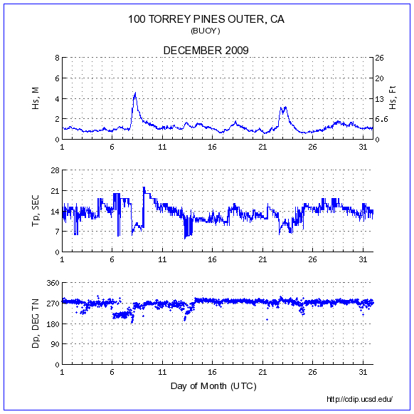
The significant height was 4.60meters (15.09feet). During such conditions an occasional extreme wave of nearly twice that height can be expected. These waves had a dominant period of 9.09seconds and were arriving from 261degrees.
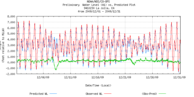
The storm system responsible for the extreme wind waves had unusually sustained winds from the south and a record-breaking low pressure. Such winds blowing towards the northwest along our coast move the water towards the coast, piling it up. Low atmospheric pressure also sucks the sea surface up in an "inverted barometer effect." We recorded a steep drop in atmospheric pressure from our normal of about 1016millibars down to 998.9millibars. This pressure drop corresponds to about 5 inches of sea level increase. These 2 phenomena are responsible for the local rise in sea surface called storm surge.
In the record below (which may take a moment to load), the green graph plots the difference of the predicted astronomical tide (red) and the observed tide (blue) for Dec '09. On the 8th, the low tide was more than 1ft higher than predicted due to storm surge. Fortunately the peak surge coincided with the first neap tides of the month, rather than the predicted solstitial spring tides of year; thus local flooding was minimized.
Wave Climate at Torrey Pines Outer Buoy:
CDIP Wave Rose Hs Dir 2001-2010
CDIP Period Rose Period Dir 2001-2010