Location
Location
The location of the station has been determined by a combination of an old survey bench mark, once located near the Visitor's Center flagpole and GPS latitude and longitude.
The few feet discrepancy between the location depicted on the map by the pointer, and the nearby corner of the building is likely due to a combination of errors in the GPS location and the google mapping system.
Barometer
The barometer is located in the local display, which is on a ranger's desk in the NW corner of the rangers' office. Its atitude is approximately referenced to the old benchmark. The sensor has been compared with a portable microbarometer at sea level to determine a sensor calibration. With these adjustments over a six month period, the mean difference of analysis less observed sea level pressure has been 1.3millibars. The standard deviation has been 0.4 millibars. One millibar roughly corresponds to 27feet of altitude difference. This mean difference is within the stated accuracy of the sensor. However we don't know whose analysis is used as the reference.
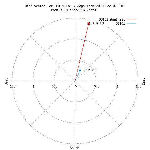
Anemometer
The anemometer is mounted on an antenna mast 8-feeet above the lower parapet of the Visitors Center. This is directly above the barometer. The wind observations are influenced by nearby trees and the upper parapet of the building. This vector display compares averaged observed and forecast wind vectors over 7 days.
Temperature-humidity sensor
The temperature-humidity sensor has been mounted in a white plastic radiation shield under the NW porch roof, outside the docents' storage room of the Visitors Center. As a condition of for participating in the San Diego Mesonet this sensor has been moved to the anemometer mast.
Rain guage
The rain guage is mounted on the flat roof over the rangers' office. It is in the open and stays free of pine needles and other debris. It is somewhat sheltered on the west.